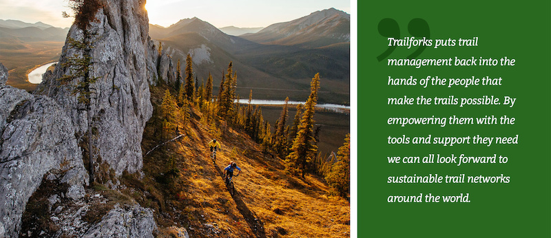
Free Camping on Bike Trips & Other Advanced Trailforks Features

Apr 10, 2018 at 12:34
by Trevor May  
trail management platform

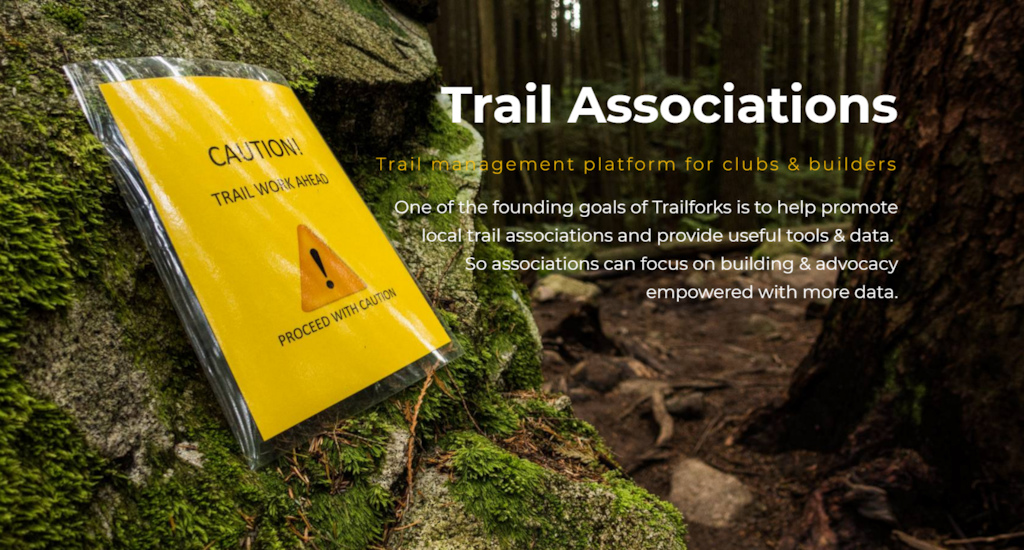
Many riders have heard about Trailforks by now and often think of it as the trail map app on your phone. But Trailforks is much more than just an app. One of the founding goals was to build a trail management system with features to empower local trail associations with data, planning & advocacy tools.


Trailforks logo

Trailforks has a large list of tools that have been created with these goals in mind, including many related to our robust trail reporting or ride log trail usage statistics systems. But here are 5 lesser-known advanced features.


Land Owner Overlays
Land owner overlay

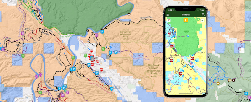
Working with Land Managers is always the first step to any trail work or maintenance, but it can sometimes be hard to understand where those boundaries are. Trailforks makes that easy. Whether you're in the field on the app or at home on the website, you can toggle on the Land Manager boundaries. Some of the Land Managers included are: the Forest Service, BLM, National Parks, Military, Indigenous Areas and any Congressional designated Wilderness Areas.

Tip: Want to camp for free? Trailforks now shows you exactly where the BLM land is.
BLM – Bureau of Land Management. Dispersed camping is allowed on most BLM land for up to 14 days. Even if land is leased or has mining claims, you may camp there unless posted otherwise by BLM management.
bigquotesRecently I was on a trip near Joshua Tree Park in California and all the spots in the park were full. I pulled out the Trailforks App, turned on land owner overlay, and followed a dirt road on BLM land to an amazing mountain top camping spot, within a mile of the park boundary. Amazing!


Heatmap Past/Current
Rideguides new rides vs old rides.

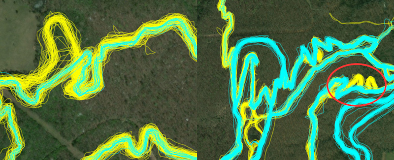
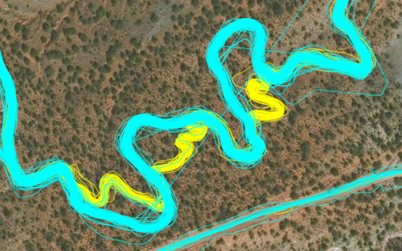
Notice in this photo marked in red shows that past tracks (yellow) follow switch backs, but all more current tracks (cyan) are now re-routed and running straight.


Many are familiar with the Trailforks heatmap and how it can be used to edit trail GPS tracks through its "ride lines" view. But we've been working hard at improving this feature. While editing a trail, you now have the option to view the historic ride lines (yellow) and the ride lines from the most current 6 months (cyan). This displays any new trends for riders as well as any new reroutes on older trails.

Mill Creek reroute to improve that first part of the climb so much better now

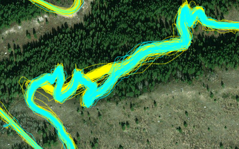
Example of an awesome reroute put in to fix that brutal climb at the start of Mill Creek. A favorite both up and down, now provides a much better climbing experience to access "The Ghee"


Wire Mesa route Thanks Jake

This is Wire Mesa where Jake Weber did some reroutes to open sight lines and widen some tight corners to create better flow. Thanks Jake!


Using the ride lines, you can edit trails' GPS tracks to be more accurate and trace where people actually ride.

Detect the following conditions easily:
• Trail re-routes
• New trails
• Old unused trails
• Improve trail GPS accuracy


Ride Start Heatmap
Ride start point heatmap

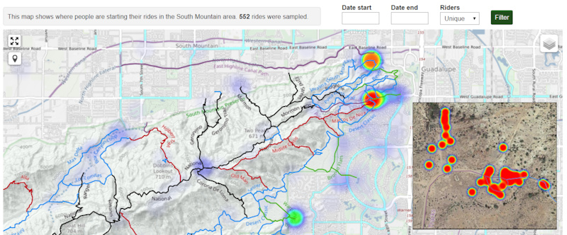
Trailforks has created a new heatmap that only shows the spot where riders have hit record on their GPS or Smartphone. The Ride Start Heatmap is great to see which parking lots are being used. Using the heatmap. you can identify potential conflict areas early on, perhaps identifying the need for new parking lots, trailheads or climbing trails. For extra privacy reasons, we do not make this feature publicly available. You will need to be given admin permissions for your region to access it via the admin page.

Views: 1,188    Faves: 3    Comments: 0


Auto-direction
Trail direction ridden stats

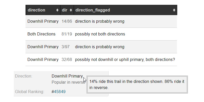
Using the user-contributed ride logs, Trailforks can now display the preferred direction of a trail. This is great to see how riders are using your network, and help trail organizations better understand which trails are used for climbing and which are used for descending.


Print Map
Print map export tool examples

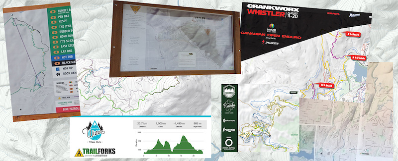
Trailforks might be a great map app, but that doesn't mean we don't see the value in a good old-fashioned paper map. Now Trailforks makes that easier. If you need a map for an event, a new trail proposal or a full-size map for a trailhead kiosk, the Trailforks Print Map Tool is a one-stop shop for all the information you need. Export high-resolution vector files of a map area for print.


Trail supporter page 2


MENTIONS: @trailforks


Author Info:
canadaka avatar

Member since Jun 8, 2010
29 articles

106 Comments
  • 74 5
 The camping ap should have a feature to identify closest washrooms and waste receptacles, to help discourage an app-driven wave of feces and garbage.....Most people may be conscientious, but nothing stops the tool from being used by dirtbags.
  • 11 0
 Good point. Something worth mentioning about camping on BLM land is that there is not water access but also you're not allowed to bury human waste which means you're supposed to pack it out. Not the most fun, but manageable if you're prepared.
  • 29 14
 @Wisco: Wow! Call me a rebel, but I might just risk burying my morning growler on BLM land.
  • 4 5
 @jbravo: I just leave it out for my doggies to play around in it. It goes away eventually.
  • 8 0
 Just in case anyone is serious about any of that, here's an easy recommendation that I use when we're in sensitive desert areas: small bucket, simple plastic trash bags, and lots of hydrogen peroxide. The H202 helps breakdown the waste matter and begin the enzyme process, which all but eliminates most of the smell that people associate with those porta potty chemical treatments. Even on 100f+ days, those bags will remain remarkably odor free and are sanitary.
  • 13 0
 Take a lidded bucket, put a kitchen bag in it, and coat the bottom with kitty litter or even more convenient sand (not as good).
Have morning coffee, poop, cover with said kitty litter or sand, and move on with your day. Does not smell if bag is tossed every 3 or so days.
Practice stealth camping to keep access to these areas open.
Pee wherever you like (usually at the 4 corners of your site if you're territorialWink
  • 1 0
 @Wisco: That's a bunch of crap.
  • 41 1
 Great app. Thanks again PB!!
  • 34 1
 Can't say this enough. Trailforks is an invaluable tool on and off the trails.

====== T H A N K S P I N K B I K E ! ! ! ================
  • 24 6
 @canadaka Amazing app, thanks so much. One feature I would kill for, is audio turn-by-turn directions when switching trails/taking a wrong turn (like GPS in a car) for Routes. This way you could easily follow a Route without having to pull your phone out all the time to check. This is something I struggle with when riding solo at new places and I would think other people would struggle with too. I believe this feature also would be awesome for people getting into the sport and for coaching. Anyways, keep up the great work, your app is a game-changer!
  • 23 1
 We might have something that will handle this issue in about a week. Stay tunned!
  • 20 8
 Might as well install traffic lights throughout the trail, too..
  • 33 0
 "Approaching drop in 50m", "Prepare for Steez" "12% climb begin in 100m" "12 Riders taking a break and blocking the trail around the next corner"
  • 7 0
 @lazyname: lol TrailWAZE...hahah see what I did there...


@Tomacboy: agreed-- audio may seem silly but if you're using TForks in a new area with lots of intersections and riding solo you do end up pulling phone out of pocket constantly, even if you try to remember ok, 2 right turns followed by left till next major trail. Audio feature would be legit!
  • 3 0
 @radek: Sounds positive! Love the app. But agree stopping every minute in a new zone that has many intersecting trails kills the flow and I'm not smart enough to remember many turns in advance...
  • 1 0
 @lazyname: "Prepare to park your bike. You will need to walk the next feature." "When possible, make a legal (endo) U-turn" And of course, the ubiquitous "Proceed to the route" or in my area, proceed to the root. Some of those I could live without. Wink
  • 13 0
 How about offline maps? I know there is a way to get offline trails but it would be nice to be able to cache a section of topo maps for offline use.
  • 14 0
 This is on our list this year, no time-line when it will be ready though.
  • 3 0
 @canadaka: Great, looking forward to it Smile
  • 3 0
 @canadaka: Awesome. I'd love to be able to cache basemaps for given polygons, since Trailforks is one of the better available selections of different basemaps in one app. I'd use it year round, skiing and biking...
  • 3 1
 THIS^^^
It is super annoying as I don't have data that although Trailforks uses google maps data, and I have all the maps stored offline in the google maps app on the same device, Trailforks can't figure out how to look at those same files!

Please fix this Trailforks!
  • 4 0
 @paulpalf: This is not something Google allows, we would if we could! The Google Maps SDK has no offline capability or permission to even use their map tiles offline. So we will have to switch map frame-works and re-write a lot of our map code.
  • 1 0
 You can use Trailforks' Garmin Maps For Mountain Biking with the Oruxmaps app. I made a quick how-to if anyone else wants to give it a try.

mvmorten.blogspot.com/2018/04/how-to-use-garmin-formatted-img-maps-on.html
  • 7 0
 Cheap cold beer. Good cheap cold beer. Thats a layer that trailforks needs.
  • 1 1
 Cooler in the back of your car! But a mountain bike dive bar guide would be pretty sweet.
  • 4 1
 First: this is a very cool app and the work done on it is excellent.

Now, let me go on my old-guy rant:

Used to be information like this was sacred. It was spread quietly by word of mouth in bike shops and trailside. Now, every trail, fishing hole, powder stash, camping spot . . . has been f!#@ked out on Facebook, Instagram, Snapsh!t, whatever. Good luck find solitude kids!!

Rant over.
  • 1 0
 Yup. Truth. Fisherman and MTB’er here.
  • 2 0
 We also have 1,000 times more trails. As someone that enjoys solitude, the trade off is still by far worth it for me. To be honest, there's so many trails now that I get places to myself more often than before cell phones were a thing and very few trails.
  • 4 0
 It would be great to have the land owner overlay populate the slide out legend when toggled on. Most of our trails are on county land, and no one has any idea of what local jurisdiction ownership is colored.
  • 1 0
 PM on it's way.
  • 3 0
 Thanks for creating a great resource for all of us! I have used it countless times to discover and navigate. One thing I would like to see is more info on each trail head parking area... especially if there are bathrooms and overnight parking allowed.
  • 3 0
 This is great, but... Why does the Android app need access to device history? That seems like a lot of unnecessary permissions for a trail app.
  • 9 0
 The "cordova-background-geolocation" plugin our app uses requires it. It only has access process owned by the app via GET_TASKS.

"The Android GET_TASKS permission has been deprecated and neutered so that
it provides access only to those processes owned by the app itself but this
is exactly what the plugin needs it for.

The plugin uses GET_TASKS in order to determine if the user closed the
MainActivity and whether it needs to forceReload it."

This is so the GPS recording can re-launch the app if it crashes while recording a ride.
  • 1 0
 I've been looking for an app to drop GPS pins to itemize trail improvements/repairs. Does anyone have anything useful thats easy to share? The goal is to hand a couple guys a punch list on trail work days and maybe send them a file with the pins and cut em loose.
  • 11 0
 This is really easy to do in Trailforks using route specific POIs. All you have to do is create a route in the route builder (draw it, link it, upload it), then assign a specific POI that will only be part of that route. People do this for race course routes all the time, like if you need race day parking that is only for race day, or feedzones that will not be there outside of a race. They markers do not show up on Traiforks for everyone, only for your race (or repair map)

You can do the same with all POIs. So you can add warnings, "sight" icons, like things to check on. I have even used this to add sign posts where they don't exist, but we need them installed. Anyone can add a route to the app by just putting it on their wishlist. Or using the printmap interface you can print out the route and it will include all of your custom points. I just print that out, hand it to my sign post digger, and he bangs it out.

On a side note, this is also great way to create "planned trails" by just drawing them in, and then going out on foot to to investigate the lines. You can add trails and mark them as planned so they appear only faintly in the map.
  • 3 0
 avenza pdf maps is good and you can attach photos. Works good if you have a pdf map to download or there is a free one in store.
  • 7 0
 @dglass: The printmap feature can generate a geotiff, which works in Avenza as well. So you can generate a full review map, or just generate the geotiff of the basemap and use Avenza pins.
  • 3 0
 @todd: That is bad ass.
  • 2 0
 @todd: I'm going to have to read that at least five times before it soaks in but I seriously appreciate the help!
  • 2 0
 super rudimentary but my crew takes a photo of the issue and then a screen shot of the location on trailforks. it take a bit of work on my end to catalog it, but its simple and works.
  • 1 0
 @todd: nice tip, thanks.
  • 2 0
 @JoeDick: Why not just create a "trail report" in the Trailforks app, you can take a photo with the report, or attach an existing photo. The report will contain a map location from your location on-trail, or the GPS location from the photos meta-data.

When viewing the report on the TF website, it will show a map with it's location. You can also view all reports on a map, filter by various things like status or date range.
  • 1 0
 @canadaka: I'll ask the question I could go figure out for my self. will this work in locations with out cell service and/or with out a data plan?
  • 1 0
 @JoeDick: Yes trail reports can be created offline, then will sync when your back online. Although our app doesn't have a background service, so you need to have the app running for the reports to sync. You can goto the trail report form and it will show a count of pending reports for upload.
  • 2 0
 @canadaka @JoeDick This is what I use and really dig it. Either my guides or trail crew creates a trail report with a photo. Then the trail crew creates a report with a before and after photo for documentation plus hours spent on the project. It's little bit clunky for me the keep track of and organize whats getting done, but works overall. An improvement that would help is to be able to label a report as "work needed" and then that report would stay active until an official reporter marks it as completed. They could update it to a "work completed" report.
  • 1 0
 On the phone app for google maps there is now 3D satellite imagery that lets you see underneath trees and see individual buildingand all that, it’s almost like a video game. Anyway... this is a great way to plan trails and recommend that everyone gives it a go.

I don’t know if it’s possible, but if this could be implemented into Trailforks it would be epic
  • 1 0
 Not sure if this is what you mean, but every region page has a 3D map on the website, example: www.trailforks.com/region/whistler/3dmap
  • 3 1
 How about street view for trails just need dudes to strap 360 degree cameras to their heads and ride down the trails! Have seen a couple of 360 videos on youtube and they are pretty great.
  • 1 0
 A little bit of a European push would be great!
The popular tracks and bike parks are mapped, but not much further than that. (in the regions I've been to at least)

Also, in Austria in particular we could use all the help we can get to fight for hiking network access. I realize this might not be your goal, but maybe there's something that could be done that'll benefit TF as well? Especially now that Innsbruck is hosting Crankworks? Could use the momentum?
  • 1 0
 Send me a message! This is exactly what we help with.
  • 1 0
 These are neat features. The trail direction one at least validates how I've marked some of the trails that I've created.

Just curious though, some trails are marked as both directions and then it says 88% of riders ride in that direction, while the remaining 12% ride in one of the other directions. What does that mean?
  • 2 0
 well just because that is how riders are actually riding it, the trail network might still want to designate the trail as both directions. But maybe they just didn't know, now with this data maybe a decision could be make to designate it primary in one of the directions.
  • 1 0
 I just used Trailforks pretty successfully in the US for two weeks of adventuring. I used free camping dot net for all my camping and will probably continue to use that in the future. Trailforks doesn’t work well with Google Maps on an iPhone. It would either prompt me to download Apple Maps or use web.
Free camping dot net gave me gps coordinates I could find with no internet access.

If Trailforks could provide GPS coordinates to parking and camping, or give me the option to open locations in Google Maps it would be a lot more friendly when I don’t have any cell reception.
  • 1 0
 There is that option, goto the Settings page in the app and you can change the directions app from Apple Maps to Google Maps. Also with the land owner overlay enabled, you can then hold and press any spot on the map to get a dialog appear with a pin on that spot. Then get driving directions to that spot.
  • 1 0
 @canadaka: that’s very helpful thank you! GPS coordinates would still be helpful though. They’re a bit more reliable than driving directions on an iPhone when you don’t have any service. I recall being able to get them on the web, is there an option to turn them on in the app?
  • 1 0
 @mmoon: When you long press on anyplace on the map it gives you gps coordinates, and then when you click get directions it opens ip google maps, apple maps, or waze with the search filled in with the gps coordinates.
I think this solves what you are looking for?

Example.
www.pinkbike.com/photo/15903247

www.pinkbike.com/photo/15903246
  • 1 0
 @radek: that solves everything. I clearly didn’t know how to use the app. Looks like I should be able to find parking lots and camp spots on the fly with no data now. Thanks!
  • 3 0
 @canadaka @todd @brenthillier Love reading these articles and learning about new capabilities. Keep them coming.
  • 1 0
 @canadaka: thank you for the awsome app!! We have it on our site and getting as many people to use the reporting tool. These guys work hard to make this the best resource for trail adovacts. Keep up the good work!!
  • 1 0
 There is no explanation of the following on the website:

•green area with trees on the map
•Arcgis
•TF
•OSM

Also, there are no instructions in the article for viewing the advertised overlay.
  • 1 0
 Wow Trailforks thanks for this! Just found a free BLM zone to camp in a couple hundred meters from Laguna Seca instead of their $75USD/night for a space in a parking lot. It was the last piece to my Sea Otter puzzle.
  • 2 0
 The land owner overlay is awesome, but how do I know what each color means?
  • 2 0
 In the app there is a legend. www.pinkbike.com/photo/15787037
But realize now the website is missing the same legend, it will be added!
  • 1 0
 In the app, it's in the legend. Here it is: www.pinkbike.com/photo/15787038
  • 1 0
 haha, you beat me to it by 1 photo!
  • 4 0
 Great stuff.
  • 2 0
 land owner overlay doesn't seem to work for me in Canada... would be an awesome tool though!
  • 2 0
 Why do you say that. It does work in canada. Parks are shown, of course there is no BLM in canada.
Additional types/landowners will be added in the future.
  • 1 0
 @radek: does it have private land boundaries? That is usually our biggest issue. What about habitat reserves like Old Growth Management Areas, Ungulate Winter Range areas, Wildlife Habitat Areas, etc. In BC you probably need to talk to your Recreation Officer for that info...
  • 1 0
 @debramac: We have a separate land owner layer that is also shown on the website that can include private bounbaries. Its also an interactive layer, powered by a Google Fusion table, so it's easy for us to update at any-time. If you have a specific request for a local land owner to be added, email brent@pinkbike.com and he can add it for you. But it will help A LOT if you already have a KML polygon of the boundary.

Here is an example of the interactive layer in New Mexico www.trailforks.com/trails/landmanager/rwa
  • 1 0
 @radek: My bad, I see now that it has provincial parks in BC. Was more so looking for boundaries between crown land and private land. Still, considering I didnt know that feature existed a few hours ago, no real complaints here! Keep up the good work!
  • 1 0
 this would all be lovely if any of the trails in ireland ( or at least near me ) were mapped so i could find them in the first place.
  • 8 0
 Yes there does seem to be a pretty low number mapped, 160. www.trailforks.com/region/ireland

You could always help map some Wink www.trailforks.com/contribute
  • 1 0
 @canadaka: Is there anyway to tell if an area has trails, that have been logged, but are marked private (due to land manager issues, unsanctioned etc)?
  • 3 1
 Really enjoy using trailforks, but I'd would to see it available on the Apple Watch 3 as well!!
  • 3 0
 Really good! Nice work!
  • 3 0
 Great!
  • 3 0
 Cheers lads good work
  • 2 0
 @canadaka you're a true wizard!!!
  • 2 0
 This is so impressive, incredible work Pinkbike!!!
  • 1 0
 Sick but BC campsite are booked a year in advance, so we really need this. Good.
  • 1 0
 camping feature is awesome! I was expecting more BLM in AZ since there is a lot of open land
  • 1 0
 How do I get on trail direction while riding? All I can get is directions to the trailhead (Directions on my Iphone)
  • 1 0
 I mean I'd like to know how to ride the trail while I'm riding in the new city I moved to...How do I do that?
  • 2 0
 sounds nice Wink good luck
  • 3 1
 Super cool work.
  • 1 0
 Any chance trailforks will add a feature that will help plan trails
  • 3 0
 You can already, a trail can be added and marked as "planned". It will show as a thinner line on the map and has a message saying its planned in the website and app.

Also a planned trail can be made hidden with a password added. So the URL can be shared with a land manager for review or approval before being built or made public on the map.
  • 1 0
 @canadaka: I was actually referring to helping with the layout, I use google earth right now for some planning, but an app made for the specific purpose of helping people make good trail layouts would be nice, or any features that make it easier. so far the only way I could build a trail would be to walk around until I find a good spot, only to realize its a terrible spot while trying to finish the trail's layout.
  • 1 0
 @DeadThrone: I have used Trail Forks for two trails laying them out on my PC. The process is: Start a new trail and pick trace trail. Set it to ARCGIS. You need to know the terrain, then draw a line based on the contour, save it on Trailforks. Go out in the field use the app to locate where you are then hang tape in the trees for the builders to use for their pin flag and build. The field work will fix any issues you didn’t see on the map. But before you go out and walk it you have approximately how the trail would like elevation gain and length. Then you can go back and walk a new GPX track.
  • 1 0
 @DeadThrone: The process @canadaka describes definitely works for planning a layout. You can see the profile and average gradient, and if you have the rights to view the planned trail, you can follow it in the app while walking on the ground. The rest of it is more than an app can do - you need to know the landscape, too.
  • 1 0
 Where is the trail in the last photo?
  • 1 0
 Somewhere in the Yukon.
  • 1 0
 @alexsin. To be more precise - Sapper Hill in the Yukon. Sorry @Canadaka I did not add it as TF trail
  • 3 1
 Heat Maps? WTF.
  • 1 0
 Thanks for Trailforks and all the continued improvements.
  • 1 0
 Heatmaps are great for finding illegal and secret trails Wink
  • 1 0
 Legend for land-owners?
  • 4 0
 On the screen where you toggle the land owner overlay, at the bottom you see "Map Legend, tips & tricks"
  • 1 0
 @radek: Thank you. Is it only working for phone apps? I was looking the website on my computer, and seems like the legend for the land owners isn't there.
  • 1 0
 @okavango: Scroll over the Layers drop down menu located on the left side of any regional map, its near the bottom of the list. Just toggle it on and off as needed.
  • 1 0
 @markholloway: I dont think the "Landowner overlay" info is on the website yet. We need to add it.
  • 1 0
 @radek: You are correct, there currently is no land owners legend on the main site. I misunderstood and thought the question was regarding the Land Owners Layer itself...
  • 1 0
 @markholloway: its on there now!
  • 2 2
 My question is, where is there any riding in Joshua Tree?


Copyright © 2000 - 2024. Pinkbike.com. All rights reserved.
dv56 0.438084
Mobile Version of Website